

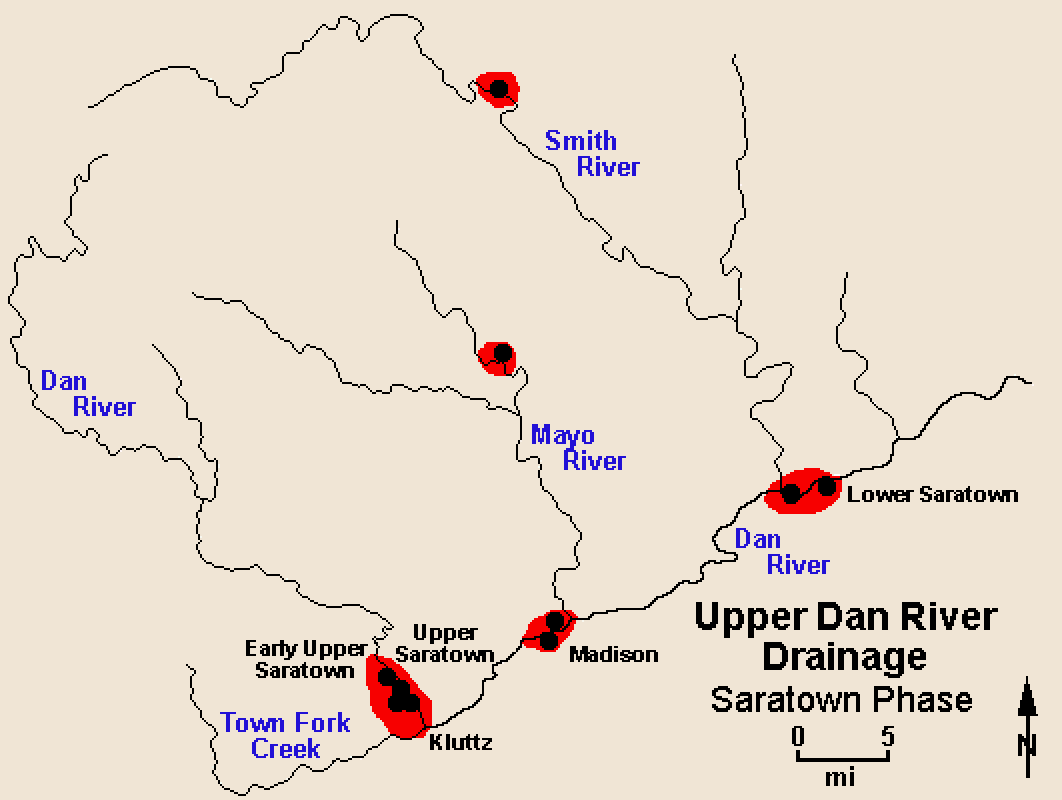
The period following the Dan River phase, and generally coinciding with the Protohistoric and Historic periods, is characterized by massive depopulation, a regional shift in settlement, and evidence of increased contact with other cultures, including the English, in adjacent regions. By about 1450, the principal tributaries as well as much of the Dan River were largely abandoned, and new settlements were established near the mouths of those tributaries (see distribution map). Pottery assemblages, which contain new vessel forms with burnished and carved paddle stamped exteriors in addition to more traditional Dan River net-impressed jars, reflect an introduction of new pottery styles from the Catawba drainage to the south.
Three subphases of the Saratown phase are recognized. The early Saratown phase (c. 1450-1620) is defined largely from excavations at the Early Upper Saratown site (31Sk1) (Wilson 1983). This site, located along Dan River near the mouth of Town Fork Creek, covers about 2.5 acres and contains both a thick, rich midden and numerous pit features. Given these attributes of site size and density of cultural material, Early Upper Saratown probably had a larger resident population than any previous Dan River phase settlement in the region.
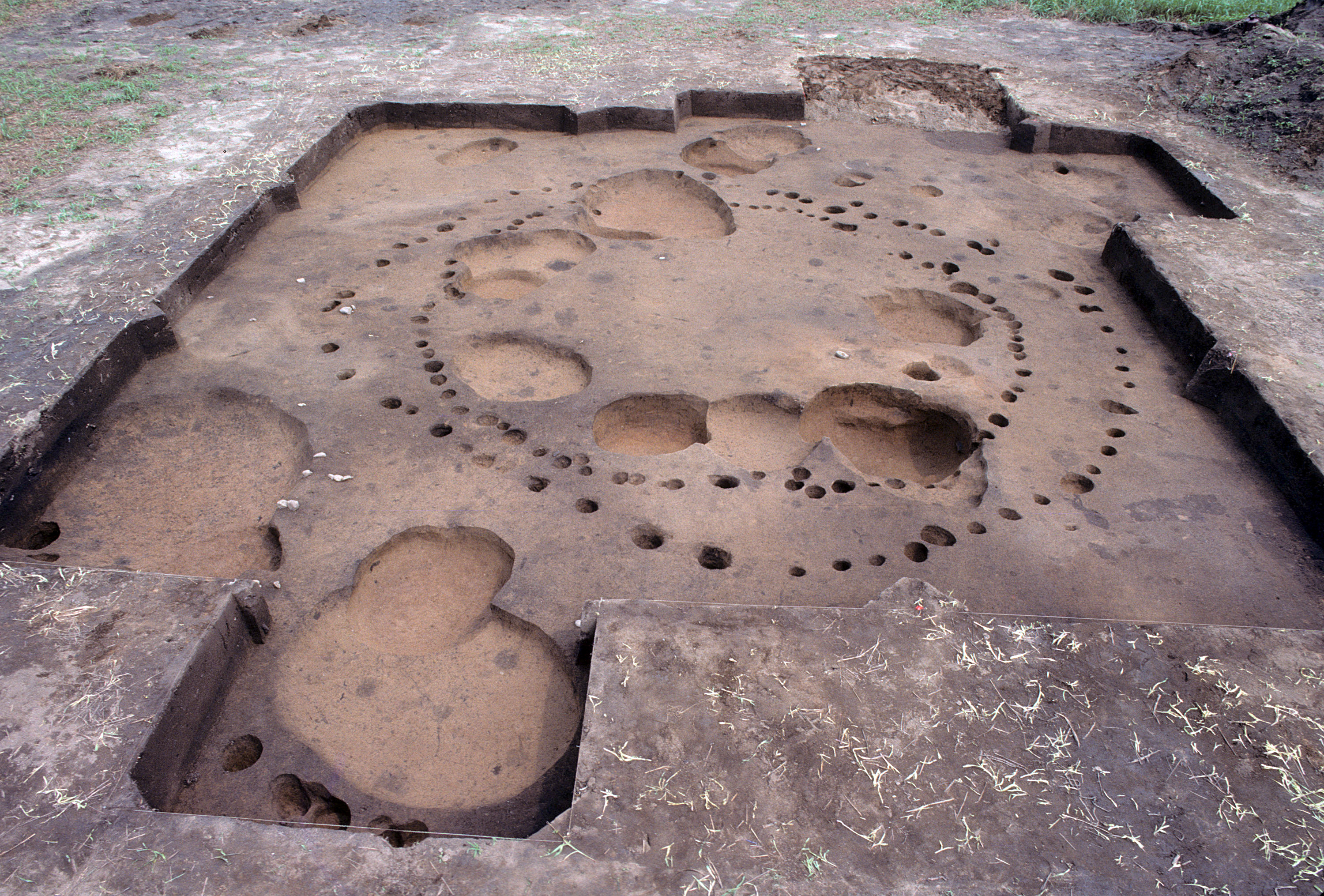
The middle Saratown phase (1620-1670), a period during which the Sara began to receive trade goods from the English and Indian intermediaries, is represented by the Lower Saratown site (31Rk1). This site is located along Dan River, just below the mouth of Smith River, and represents a compact, palisaded village, probably with an internal structure similar to that documented for earlier Dan River phase villages. This village covered about 1.5 acres. To date, only one house has been identified at this site. It is a sub-rectangular structure that measures 20 ft by 23 ft and contained a central hearth and numerous storage pits along the interior wall (see excavated house).
Finally, the late Saratown phase (1670-1710) represents the terminal Sara occupation of the upper Dan River drainage, and is well documented by extensive excavations at the Upper Saratown site (31Sk1a), limited testing at the nearby Kluttz site (31Sk6), and donated collections and records from the Madison site (31Rk6). It is significant that all three of these sites resemble large cemeteries more than villages. In fact, the Madison site has previously been regarded as a cemetery rather than a habitation site based on the extremely high density of burials there (Gravely 1969). Testing at the Kluttz site also revealed a probable cemetery area that contained numerous shallow graves. The latter seventeenth century clearly was a time of death among the Sara.
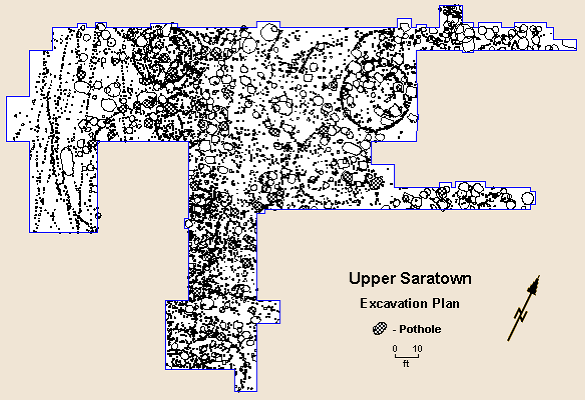
Settlement structure during the late Saratown phase is best known from the Upper Saratown site, located just downstream from Early Upper Saratown (Ward 1980; Wilson 1983). Approximately one-fourth of this site has been excavated, exposing portions of at least 13 houses, 225 pit features, and 111 burials (see excavation plan). Upper Saratown also was a palisaded village, covering about 1.5 acres, and probably contained 20 to 25 households, or a maximum of 200 to 250 individuals. Houses were circular and ranged from 20 ft to 30 ft in diameter. Storage pits and burials often were dug into house floors, but also were placed elsewhere.
Given present evidence, the final Sara occupation appears to have been at the Kluttz site, located just downstream from Upper Saratown. The large number of burials found here suggests that the mortality rate continued to remain high. However, the intrasite settlement plan apparently shifted from a compact nucleated village to one consisting of more widely dispersed households over a 6.5-acre area. Furthermore, the marked stylistic diversity within the pottery from the site suggests that the Kluttz site may represent a refuge community that incorporated different Siouan groups. Following this occupation, the Sara retreated to the southeast where they joined the Catawba along the lower Catawba River.